In the course of preparing to write my Arthurian series, I had to do a lot of research regarding how Britain changed from when it was under Roman control to how it looked after they withdrew. It amazes me just how radically different it became in just the span of roughly a hundred years. At its peak, it’s estimated that Roman Britain had 3 – 4 million people living there. By the 5th century, there was likely only around 1.5 million. The Doomsday Book, written in 1066, gives us a population of 2 million.
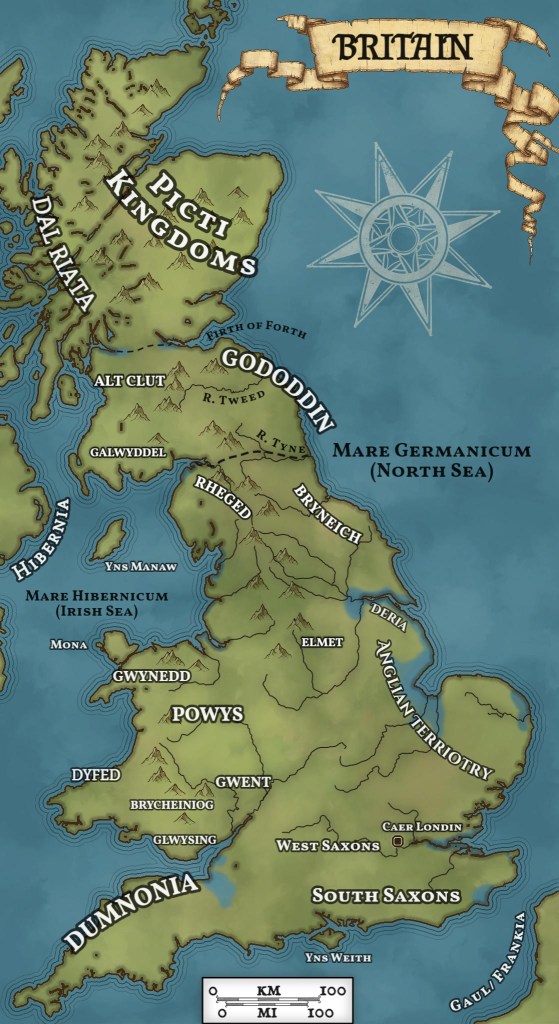
So along with an absolute population collapse as Romans abandoned the province, death from disease and plague, and the likely wars of conquest, tribal identities resurfaced. I’m sure that in the western regions, Roman culture was never dominant anyway, though I’d guess that it was more prevalent among the wealthy and elites. History gets really hazy about life in Post-Roman Britain though, with only a handful of sources to go off of between 400 – 800 A.D. And those sources are regarded a bit dubiously- more so than they deserve, in my opinion.
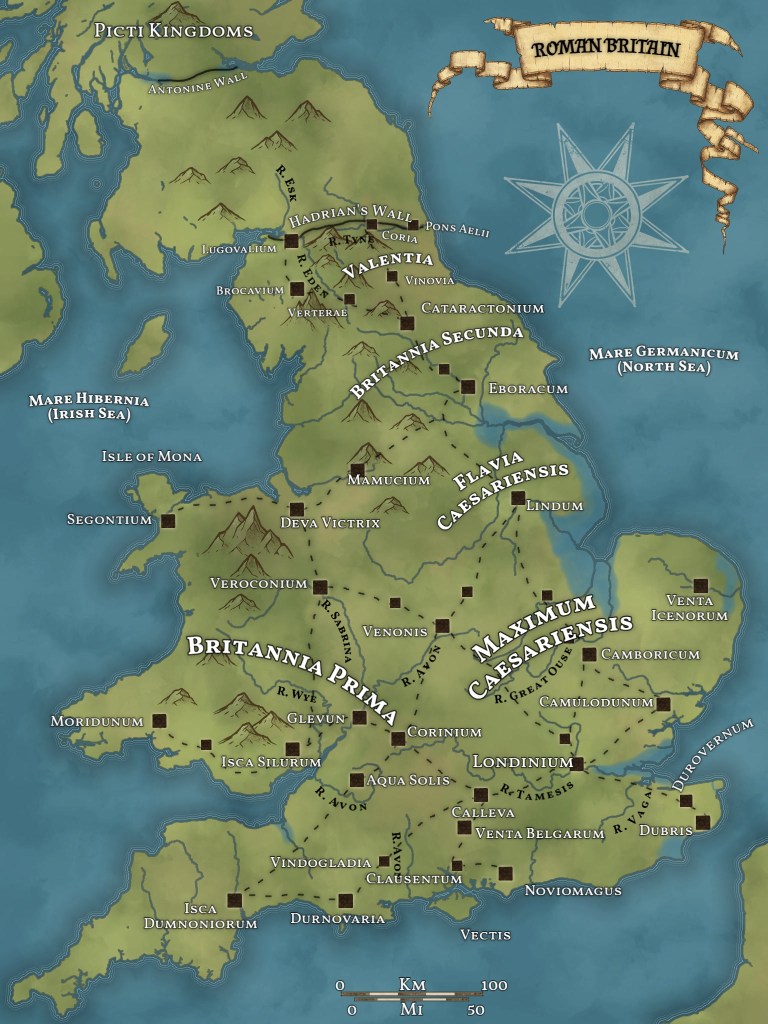
The situation in Britain seems to have been so chaotic, and details are so scarce, that we barely even know what kingdoms existed at any given time, let alone who ruled, or what their boundaries were. Tracking the development of towns gets even harder. We can see what prominent towns and forts existed in the Roman period, but the next solid lead we get doesn’t come along until Nennius, the 9th century Welsh monk, lists his twenty-eight or thirty-three (depending on the translation) cities of Britain. This is what I relied heavily on when determining what names to use in my Arthurian series that I’ve begun writing. There are a few cities that historians can’t figure out the modern (or Roman) names of from Nennius’s list, but most of them correspond readily enough to a Roman or modern town (or both). For the sake of authenticity, I try to use period place names for towns, regions, and even geographical features like rivers if I think I know what Britons called it about the 6th century. Where records didn’t provide a name, I used the Latin name. Only in the absence of the knowledge of either the Brythonic or Latin name for a place did I resort to using modern names. This occurs more often for places in Scotland, I’ve found.
Lastly, I discovered that the coastline of Britain was different in ancient times versus how it looks today. This is due to drainage done by later British monarchs, especially Queen Elizabeth I, to increase farmable land. I represented this by shading in areas of land (particularly on the east coast) that were, if not underwater, then at least very wet, mostly unusable land in 500 A.D. It fascinated the hell out of me when I realized that the placement of various roads and towns built by the Romans made more sense once I added in the details of that correct coastline.
Anyway, this is all stuff I’ve learned in the course of my research. I hope you find it fascinating as well. 🙂

Leave a comment